Madrid Río: the city's riverfront park along the Manzanares
What is Madrid Río and is it worth visiting?
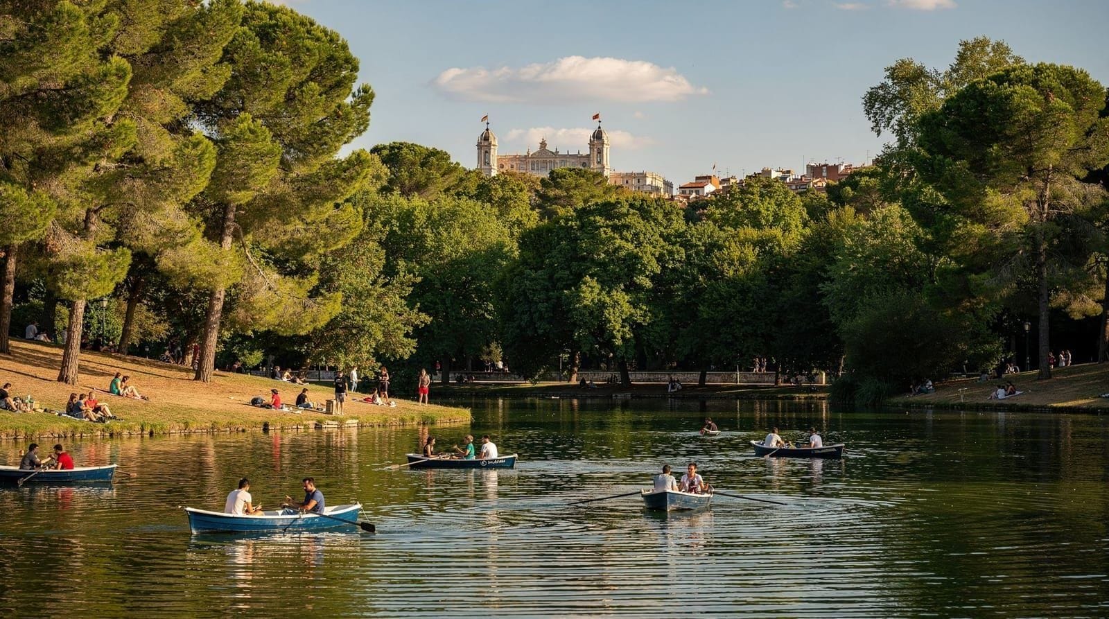
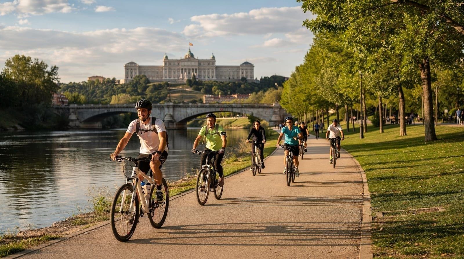
Madrid Río is a 10 km linear park created in 2011 along both banks of the Manzanares river, after the M-30 motorway was placed in a tunnel. It is one of Madrid's largest recent infrastructure investments — cycling and walking paths, playgrounds, outdoor pools (summer), urban beaches, 33 footbridges, and views back toward the Royal Palace and the historic skyline. Free to access. Best for cycling, jogging, family outings, and the outdoor pool area in summer. Connects to Casa de Campo on the west bank.
Madrid Río is the clearest example of how the city reinvented a piece of infrastructure most residents had written off. What was a highway is now a 10 km riverside park that Madrid actually uses — for cycling, jogging, family weekends, and, in summer, for cooling off at the outdoor pools. It costs nothing to visit and rewards an unhurried afternoon more than a rushed hour.
| Where | Both banks of the Manzanares, west of the historic centre |
| Cost | Free; outdoor pools around €4–6 in summer |
| Length | 10 km linear park, up to 20 km full circuit |
| Getting there | Metro to Príncipe Pío, Marqués de Vadillo, or Legazpi |
| Best time | Spring or early evening in summer |
The motorway that became a park
Until 2007, the M-30 ring road ran along the surface of the Manzanares river valley — a dual carriageway that effectively cut off the city centre from its river. The river itself was neglected: low-flow, dirty, flanked by a highway on both sides.
The decision to bury the M-30 in a tunnel and reclaim the surface for public use was the most significant urban infrastructure project in Madrid’s recent history. Between 2007 and 2011, 9 km of highway were moved underground at a cost of approximately €4 billion. The surface was redesigned by landscape architecture firms West 8 (Dutch) and Burgos & Garrido (Spanish) into a 10 km linear park on both banks of the river.
The result — Madrid Río — won multiple international urban design awards and transformed the western edge of the city centre. It is now one of Madrid’s most-used outdoor spaces, particularly by joggers, cyclists, and families on weekends.
What the park offers
Cycling and jogging paths: The park has a 20 km circuit of cycling and running paths that run the full length of both banks, with connections to Casa de Campo to the west and to the Matadero Madrid cultural centre to the southeast. The paths are flat, well-maintained, and separated from pedestrian traffic. BiciMAD docking stations are positioned along the route.
The Arganzuela Footbridge: A helical pedestrian bridge connecting the two banks, designed by Dominique Perrault. Visually striking; the spiral form creates a 200 m covered passageway with views in all directions. Photographs well.
Outdoor pools (summer): The Madrid Río park includes three outdoor municipal pools open June–September: Piscina Parque Lineal del Manzanares (on the Arganzuela bank), and two others in the Casa de Campo integration zone. Entry approximately €4–6 adults. The pools have lawn areas, changing rooms, and kiosks. In July and August they function as the western equivalent of the Casa de Campo Lago pools — full by 11:00 on hot weekend days.
Urban beach areas: The southern section of Madrid Río near Matadero has gravelled beach areas along the river’s edge, used for sunbathing in summer. The Manzanares has been cleaned significantly — water quality is now regularly monitored and the river is visually presentable, though swimming in the river itself is not officially permitted.
Playgrounds: Madrid Río has some of the most extensive and best-designed playground infrastructure in the city. Multiple large playgrounds along both banks, designed for different age groups. The area near the Puente de Segovia (Segovia bridge) has the largest concentration.
Matadero Madrid: At the southern end of the park (Paseo de la Chopera 10), the converted 19th-century slaughterhouse is now a major cultural centre — contemporary performance, cinema, exhibitions, markets, and events. Often free or low-cost. Worth checking the programme at mataderomadrid.org.
The Royal Palace views
The most photographed aspect of Madrid Río is the view it provides of the Royal Palace (Palacio Real) from the west bank of the Manzanares. The palace sits on the high ground above the river valley, visible from multiple points along the park — the view from the Puente del Rey (King’s Bridge) and from the opposite Casa de Campo bank gives the most dramatic perspective: the full mass of the Bourbon palace in white limestone, rising above the valley and visible across the river.
This view is not available from within the historic centre (the palace sits on the western edge of the city, facing away from central Madrid). Madrid Río is the place to see the palace in its full urban-topographic context. Best for photography: early morning light from the east, or late afternoon from the west. In spring and autumn the lower sun angle is particularly good.
Getting to Madrid Río
Metro: Multiple stations depending on which section you want:
- Príncipe Pío (Lines 6 and 10, also Cercanías): northern section near the Palacio Real views and Casa de Campo cable car
- Marqués de Vadillo (Line 5): central section, near the Arganzuela bridge
- Matadero/Legazpi (Line 3): southern section, Matadero Madrid
On foot from Puerta del Sol: 30 minutes west, crossing the historic centre and descending to the river valley. Relatively easy walk, mostly flat with a descent at the end.
By bicycle: BiciMAD electric bikes are available from stations throughout central Madrid; riding to Madrid Río takes 15–25 minutes depending on starting point.
The Manzanares: the river’s transformation
Madrid’s relationship with the Manzanares river has long been ambivalent. The river is small — its flow in summer can be barely a trickle — and the city historically turned its back on the water. Cervantes called it a river “by courtesy only” (aprender a nadar or you drown trying, the joke went, because there is barely enough water). The French writer Alexandre Dumas, visiting Madrid in the 19th century, is said to have suggested the city should sell its bridge and buy a river.
The post-2011 investment in water quality and flow management has changed this somewhat. The Manzanares now runs with better consistency, the banks are clean, fish have returned (anglers regularly use the southern stretch), and the river has become a genuine feature rather than an embarrassment. It remains modest by European capital standards — nothing like the Seine or the Danube — but Madrid Río has made it a genuine urban amenity.
Cycling the full Madrid Río route
The complete north–south route along Madrid Río, from the Parque de Pradolongo in the south to the Puente de los Franceses in the north (the entry to the Casa de Campo), covers approximately 10 km on each bank, for a maximum circuit of around 20 km.
Recommended route (12 km, 1–1.5 hours cycling):
- Start at Príncipe Pío (northern end, Metro Line 6/10)
- Cross to the west bank via the Puente del Rey
- Ride south on the Paseo de la Ermita del Santo
- Cross back via the Arganzuela spiral bridge
- Continue south to Matadero Madrid (cultural centre, possible stop)
- Return north on the east bank
- End at Puente del Rey or continue to link with the Parque del Oeste
Elevation: Essentially flat throughout — this is the river valley. Suitable for all fitness levels including families with children on bikes.
For the cycling-focused Madrid experience, including e-bike hire options and routes combining Madrid Río with the Retiro and Parque del Oeste, see Madrid by bike. For a fuller breakdown of the route point by point, distances, and access points, see the dedicated Madrid Río cycling guide.
If you’d rather not navigate independently, a guided e-bike ride covers the riverside and Casa de Campo with context on the bridges and the palace views built in:
Madrid Río and Casa de Campo e-bike tourSeasonal character
Spring (March–May): Best season for Madrid Río. Mild temperatures, trees and flowering shrubs in bloom along the banks, river at good flow levels. The park feels proportionate — used but not overwhelming.
Summer (June–August): The outdoor pools open and the park becomes a practical response to the heat. Early mornings (07:00–09:00) and evenings (19:00–21:00) are the recommended times for walking and cycling. Midday is genuinely hot and the exposed sections of the river path have limited shade.
Autumn (September–October): Second-best season. Lower temperatures, good light for photography, the river in its autumnal character. Less crowded than spring.
Winter (November–February): Cold and quiet. The park is largely empty but the views of the Royal Palace from the opposite bank in clear winter light are outstanding. The outdoor pools close by October; the basic infrastructure (paths, bridges, playgrounds) remains open.
Practical information
Entry: Free, open all hours (no gates)
Facilities: Bar-restaurants at several points, notably near the Matadero and the northern Lago sections. Toilets in the park service buildings. BiciMAD hire points.
Accessibility: The park paths are fully accessible for wheelchair users; the spiral bridge is an exception (steps within the helix). Most of the park is on flat or gently graded surfaces.
Connections: Madrid Río connects directly to Casa de Campo via multiple bridges and paths on the western bank, and to Parque del Oeste via the northern section near Príncipe Pío. The Matadero Madrid connection at the south end links to the Legazpi and Arganzuela districts.
Nighttime and evening in Madrid Río
After dark, Madrid Río changes character. The outdoor pools close at sunset; the cycling and running crowds thin; the bar terraces near Matadero and the northern sections fill for evening drinks.
The area around Matadero Madrid is particularly active on summer evenings — the cultural centre’s programme often extends outdoors, and the terraces around the Paseo de la Chopera have a local rather than tourist character. This is not a polished rooftop bar scene; it’s a neighbourhood evening.
Summer evening walk: The stretch from the Puente de la Princesa (near Príncipe Pío) south to the Arganzuela bridge is pleasant after 20:00 when the worst of the summer heat has passed. The Royal Palace view from the west bank is enhanced by evening light. Allow 45–60 minutes for a comfortable walk.
Madrid Río and flood management
The Manzanares is not a powerful river but it is susceptible to flash flooding, particularly in autumn and early winter when storms over the Guadarrama mountains send high water downstream. The Madrid Río park design incorporated flood management features — the river channel in the park section is designed to accommodate significant flow increases without threatening the park infrastructure.
On high-water days, sections of the park near the water’s edge are closed. This happens 3–5 times per year on average and lasts 24–72 hours. Check local news before planning a visit in autumn following heavy rain.
The 33 bridges: architecture of connection
One of the deliberate design decisions in Madrid Río was to create multiple crossing points between the two banks, at a higher frequency than the old highway allowed. The park has 33 bridges of various sizes and types, creating a route network where you can cross continuously as you walk north–south.
The architecturally notable bridges:
- Puente de Segovia (Calle de Segovia): A 16th-century bridge designed by Juan de Herrera — the same architect as El Escorial. The oldest bridge in Madrid, originally built for the Habsburg court. The bridge predates the current park by 400 years and provides a striking historical contrast with the 21st-century park infrastructure.
- Puente del Rey: A new pedestrian bridge at the northern end of Madrid Río, connecting to the Parque del Oeste approach. Modern design, clean lines, exceptional Royal Palace views.
- Puente de la Arganzuela (the spiral bridge): Designed by Dominique Perrault, helical structure — 200 m long covered walkway that crosses the river in a geometric curve. Interior photographs well; acoustics are unusual (the tube amplifies sound).
Walking the full park from north to south while crossing and recrossing via different bridges is a way to see the full range of Madrid Río’s architecture and engineering without the focused athletic commitment of the cycling circuit.
Connecting the park to the rest of Madrid
Madrid Río is positioned as the hinge between western Madrid (Casa de Campo, Parque del Oeste, the Temple of Debod) and the historic centre — the Royal Palace is 5 minutes from the river on its high ground, the Austrias district is 15 minutes’ walk east.
A useful west–east itinerary that uses Madrid Río as a throughway: Casa de Campo (morning, cycling or lake visit) → Madrid Río (crossing and walking the river park) → Royal Palace (afternoon) → Austrias quarter and Plaza Mayor (early evening). This covers the city’s western outdoor infrastructure and its most historic district in a single long day, with the river crossing providing a physical and conceptual break between natural and historical spaces.
See free things to do in Madrid for how to combine Madrid Río with other no-cost Madrid experiences.
Madrid Río for a first-time visitor with limited time
If you only have an hour or two, prioritise the stretch between Puente de Segovia and Puente del Rey — it packs in the best Royal Palace views, the Arganzuela spiral bridge (worth a short detour south from this section), and easy access back to the historic centre. Skip the far southern Matadero end and the far northern Casa de Campo extension unless cycling; on foot, they add distance without adding much beyond what the central section already shows you.
A realistic one-hour visit: enter near Príncipe Pío, walk south along the west bank to the Puente del Rey, cross for the classic palace view, continue to the Puente de Segovia, and exit east into the historic centre via Calle Segovia — roughly a 35–40 minute walk with time to stop for photographs.
How Madrid Río fits families and budget travel
Because entry and the paths are free, Madrid Río is one of the better low-cost options for a family day, alongside free things to do in Madrid and the broader strategies in the Madrid on a budget guide. The main paid element — the outdoor pools in summer — is modestly priced compared with most family activities in the city, and the playgrounds cost nothing at all. See the Madrid with kids guide for how Madrid Río compares with the city’s other family-friendly parks.
Frequently asked questions about Madrid Río
Can you swim in the Manzanares river itself?
No — swimming in the river is not officially permitted, despite the improved water quality since the M-30 project. The outdoor municipal pools within the Madrid Río park (open June–September) are the sanctioned way to cool off, and they’re separate, chlorinated facilities rather than the river itself.
Is Madrid Río worth visiting outside of summer?
Yes, arguably more so for photography and a peaceful walk. Spring brings flowering shrubs and good river flow; autumn offers similar mild conditions with fewer crowds; winter is quiet, but clear-light views of the Royal Palace from the opposite bank are some of the best of the year. Summer is best if the pools and the evening social scene near Matadero are the draw.