Cycling Madrid Río: the complete riverside route guide
How long is the Madrid Río cycling path and where does it start?
The Madrid Río linear park runs approximately 50 km in total, with the main urban cycling section covering around 30 km between the Puente de Toledo in the south and the Puente del Rey in the north, continuing to Casa de Campo. The path is flat, car-free, well-maintained, and free to use. Accessible by BiciMAD public e-bikes or rental bikes.
In brief: Madrid Río is one of the best urban cycling routes in southern Europe — long, flat, car-free, and genuinely scenic. The path follows the Manzanares river through neighborhoods that most tourists never see, with the Palacio Real visible from above for several kilometers. On a Sunday morning, it is where Madrid goes to exercise.
| Where | Along the Manzanares river, Puente de Praga to Casa de Campo |
| Distance | Main cycling section around 8–15 km, full circuit around 20 km |
| Cost | Free path; BiciMAD or rental bikes are the main expense |
| Terrain | Flat, paved, car-free throughout |
| Best time | Early morning or weekday to avoid Sunday crowds |
What Madrid Río is
Madrid Río is the transformation of the M-30 motorway — previously an elevated highway running through the city along the Manzanares river — into a linear park. The M-30 was buried underground in a project completed between 2007 and 2011, freeing 600 hectares of riverfront land for public space.
The result is one of the largest recent urban park projects in Europe: 30+ km of park along both banks of the Manzanares, with pedestrian and cycling paths, sports facilities, playgrounds, swimming areas in summer, and a series of bridges designed by architects including Dominique Perrault.
For cyclists, Madrid Río is the backbone of Madrid’s cycling network. The path is:
- Almost entirely flat (the Manzanares is at the foot of the city’s natural slope)
- Completely car-free
- Well-surfaced with tarmac throughout
- Lit at night
- Connected to BiciMAD docking stations at multiple access points
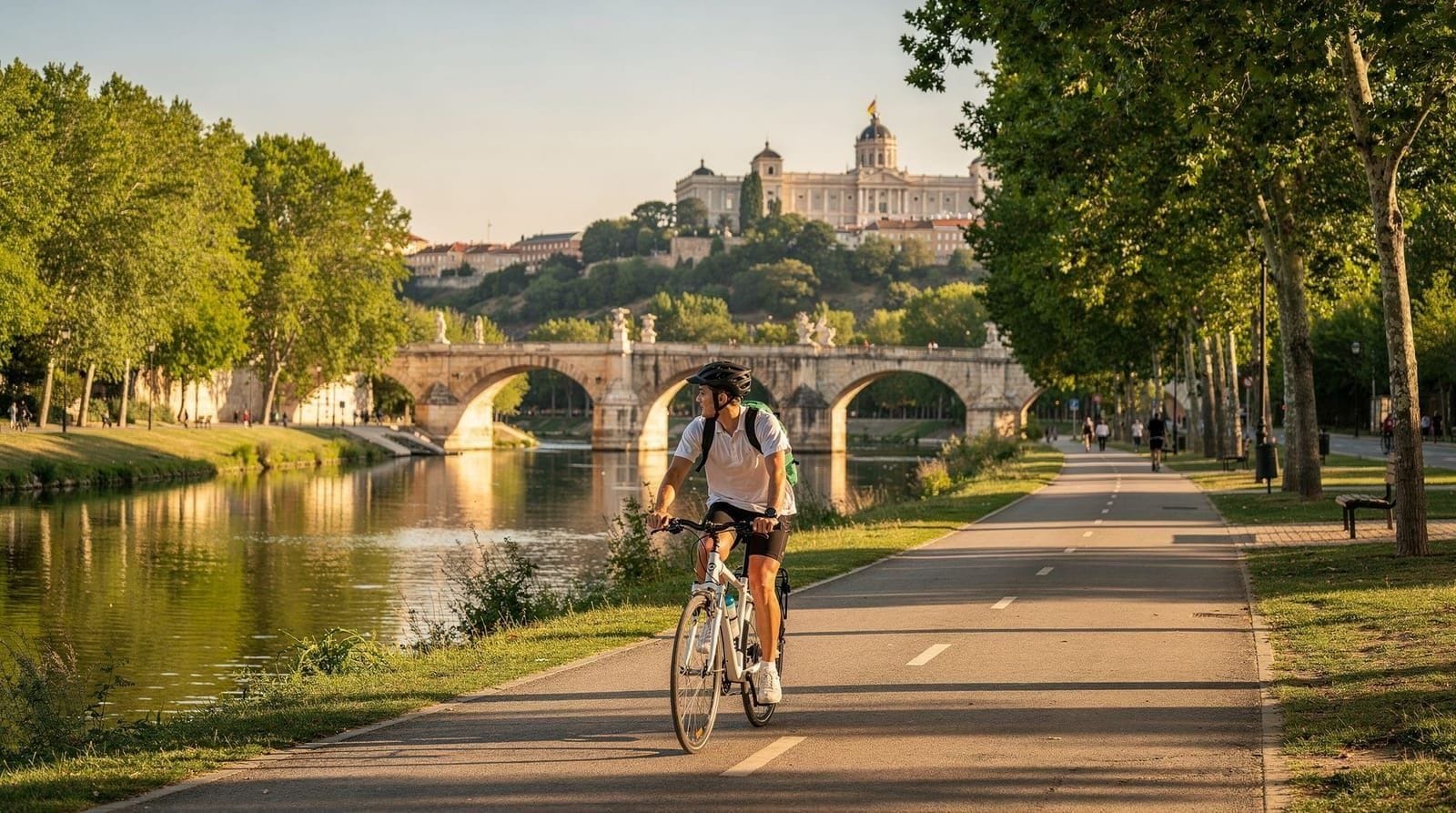
The path runs from Puente de Praga in the southeast (near the old slaughterhouse/Matadero arts complex) through the city’s western edge, under the Puente de Segovia, past the Royal Palace above, continuing northwest toward Casa de Campo and beyond.
The main cycling section: point by point
The most practical cycling section for a visitor is approximately 8–15 km depending on your start and end point. Here is a south-to-north breakdown of the key landmarks:
Matadero Madrid and Puente de Praga (southeastern entry)
The Matadero de Madrid — the former municipal slaughterhouse, now an arts and culture center — is the southern anchor of the Madrid Río park. Large red-brick industrial buildings, open-air spaces used for music and events, and a Sunday market. Good starting point if you are coming from Legazpi (Metro Line 3 or Line 6).
The Puente de Praga is a historic iron bridge here (1880s); the more dramatic Puente de Arganzuela — a double-helix pedestrian and cycling bridge by Dominique Perrault — is 500 meters south. Worth cycling across for the views.
Arganzuela stretch
The section from Puente de Arganzuela north to Puente de Toledo passes through the Parque de Pradolongo and connects to Madrid’s southern working-class neighborhoods. This section is less visited by tourists but pleasant — wide paths, benches, picnic areas.
Puente de Toledo
The Puente de Toledo (1732, baroque) is one of Madrid’s oldest and most ornate bridges — statues of San Isidro and Santa María de la Cabeza on the parapet. Worth stopping to appreciate. The area around the bridge connects north to the Latina neighborhood (see the La Latina guide).
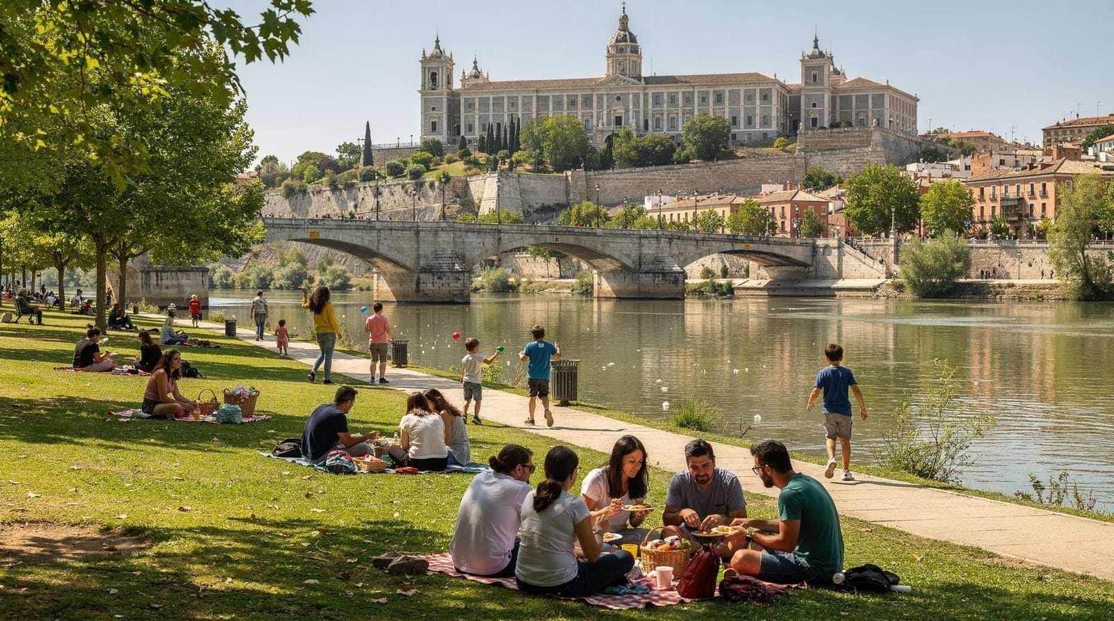
Under the Royal Palace: the most dramatic section
As you cycle north from Puente de Toledo, the Palacio Real appears above you on the western escarpment of the historic city. The view from river level looking up at the palace complex — the white façade of the Royal Palace, the dome of the Almudena Cathedral, the Torre de Madrid tower behind — is one of Madrid’s best viewpoints and completely invisible from the tourist circuit above.
This section of Madrid Río is the most photographically striking. Stop at the Jardines de Sabatini viewpoint area or on the Puente de Segovia (1584, Madrid’s oldest bridge) for the classic shot.
The Puente de Segovia itself is a worthwhile stop — 9 arches, Castilian granite, built under Felipe II. From the bridge, looking upstream (south), the Royal Palace façade is directly ahead. This view appears in countless photographs of Madrid.
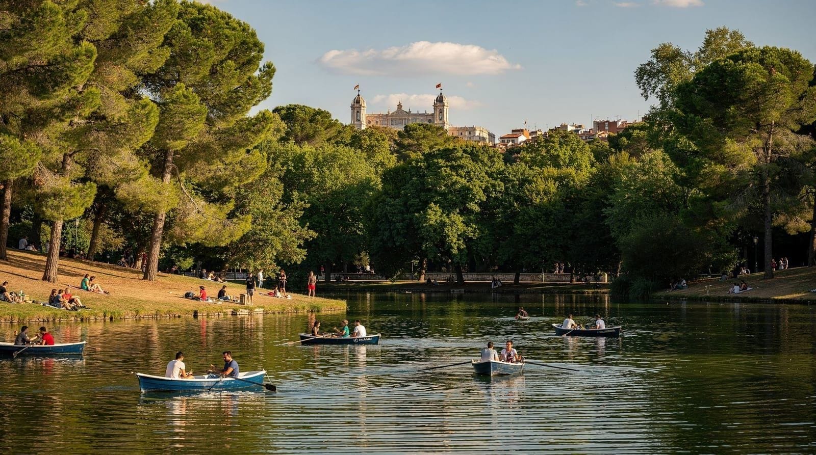
Puente del Rey and Casa de Campo junction
The Puente del Rey is a modern pedestrian bridge connecting Madrid Río to Casa de Campo — Madrid’s largest park (17 km²) to the west. At this junction, you can:
- Turn west across the Puente del Rey into Casa de Campo (extension adds 5–15 km depending on how far you go)
- Continue north along the river toward Argüelles and beyond
- End the ride here and return south (the path is symmetric)
Practical distances and times
| Section | Distance | Casual cycling time |
|---|---|---|
| Puente de Toledo to Puente del Rey | ~5 km | 20–30 min |
| Puente de Arganzuela to Puente del Rey | ~7 km | 30–40 min |
| Matadero to Casa de Campo junction | ~10 km | 45–60 min |
| Full Madrid Río main circuit (return) | ~20 km | 90–120 min |
These are casual cycling times at 12–15 km/h — the pace most visitors are comfortable with on a city path shared with pedestrians and runners. Serious cyclists doing the route at 25+ km/h will halve these times.
Access points and BiciMAD docking stations
Southern entry (Arganzuela/Legazpi):
- Metro: Line 3 to Legazpi or Line 6 to Arganzuela
- BiciMAD stations at: Legazpi station, Paseo de la Chopera (by Matadero), Puente de Toledo end
Central section (La Latina/Palacio Real side):
- Metro: Line 5 to La Latina, walk west to the river (10–15 min)
- BiciMAD stations at: Puente de Toledo north side, Paseo de los Olmos, Puerta del Ángel
Northern entry (Príncipe Pío/Casa de Campo):
- Metro: Line 6 or Line 10 to Príncipe Pío, walk west to the river (8 min)
- BiciMAD stations at: Paseo de la Ermita del Santo, Príncipe Pío
Cycling Madrid Río independently vs on a guided tour
Independent (BiciMAD or rental bike): Most practical for experienced urban cyclists who are comfortable with map navigation. The route itself is signposted, though the signage is in Spanish and some junctions are ambiguous. Download the Madrid Río map from the Ayuntamiento de Madrid website before you go.
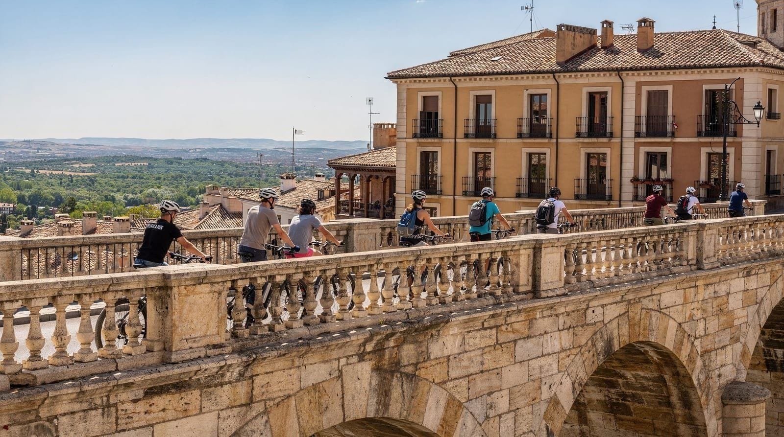
Guided tour: Some e-bike tour operators include Madrid Río as part of their route — see the e-bike tours guide for options. The guide provides context for what you are seeing above (the palace, the bridges, the neighborhoods on each bank) that enriches the ride, and it removes the navigation guesswork on a first visit:
Madrid Río and Casa de Campo e-bike tourFor visitors who want cycling combined with the historic centre rather than the riverside specifically, a shorter guided ride covers the main landmarks in about three hours:
Madrid highlights 3-hour cycling tourMadrid Río for families with children
Madrid Río is one of the best family destinations in Madrid:
Children’s areas: Multiple dedicated playgrounds along the route, including the elaborate Parque de la Arganzuela play complex with water features (operational in summer).
Swimming areas: The Madrid Río pools — open-air municipal pools along the Manzanares in summer — provide supervised swimming for a nominal fee (€3–5). See the summer rooftop pools guide for context on Madrid’s summer swimming options.
Flat cycling: The flat terrain makes it accessible for children who can ride a bike but are not strong climbers.
Food: Multiple cafés and kiosks along the route, particularly in the Arganzuela and Palacio Real sections.
Bike rental for children: Rental shops at the Parque de Pradolongo and near the Matadero offer children’s bikes and tandems by the hour.
The former Vicente Calderón stadium site
For football history visitors: the site of the Estadio Vicente Calderón — Atlético de Madrid’s home from 1966 to 2017 — is on the Madrid Río path between the Puente de Toledo and Puente de los Pinos. The stadium was demolished in 2019–2022.
The footprint is now being integrated into the Madrid Río park. As of 2026, the site shows the transition between demolition and parkland — some residual structural elements remain, with new plantings and paths. For Atlético fans, cycling through this section has a particular resonance.
What to eat along Madrid Río
Madrid Río does not have upscale restaurant infrastructure along the path — it is a public park, not a commercial development. What it does have:
Kiosks and food trucks: Distributed at key access points. Acceptable coffee, cold drinks, and light snacks. Quality is functional rather than culinary.
Matadero complex: The Matadero has a café and occasional food market events. Quality is higher than path kiosks.
Neighborhood restaurants at exit points: The most practical approach is to leave the path when you are hungry and eat in the adjacent neighborhood. Arganzuela/Legazpi has good traditional tapas bars. La Latina (a 10-minute ride east from the path) is one of Madrid’s best tapas zones — see the La Latina guide.
Renting a bike: BiciMAD vs private rental
BiciMAD (Madrid’s public bike-share system) is the most convenient option for a one-off ride. Electric-assist by default, docked at stations roughly every few hundred metres along the route, and payable by app for occasional users (a short-term pass covers a day of unlimited rides under 30 minutes each, with a small surcharge for longer stretches). The catch: BiciMAD is designed for short hops between docks, not a leisurely multi-hour ride, so the pricing structure penalises a slow, stop-and-photograph pace along Madrid Río.
Private rental shops near the Matadero and Príncipe Pío offer standard and electric bikes by the hour or day, without the docking-station time pressure. This suits a relaxed cycling day better than BiciMAD, at a modestly higher cost. Some shops also rent children’s bikes, tandems, and trailers — useful for the family sections described below.
Bringing your own bike works too if you’re staying somewhere with storage; Madrid Río has no bike-specific access restrictions, and most hotels in Arganzuela, La Latina, and Chamberí can store a bike overnight. For a broader look at cycling across the whole city, not just the riverside, see the Madrid by bike guide; if you’d rather rely on the Metro for the rest of your trip, the getting around by Metro guide covers the network Madrid Río connects into.
A realistic half-day route
For a first-time visitor with about three hours, the most rewarding stretch is Matadero → Puente de Toledo → under the Royal Palace → Puente del Rey → a short loop into Casa de Campo → back the same way. That’s roughly 14–16 km round trip at a casual pace, taking in the two most photogenic sections (the historic bridges and the palace view) without the longer, less scenic stretches toward the far south or the suburban north. Add 20–30 minutes if you stop to explore the Matadero or a Casa de Campo viewpoint. Combine it with lunch in La Latina afterward, a 10-minute ride east from the Puente de Toledo exit.
Frequently asked questions about Madrid Río cycling
Is Madrid Río suitable for road bikes?
Yes — the surface is smooth tarmac throughout the main cycling sections. However, the path is shared with pedestrians and often crowded, making high-speed road cycling inappropriate. Mountain bikes and hybrid bikes are the most common; BiciMAD e-bikes work perfectly.
Can I cycle to Retiro Park from Madrid Río?
Not directly by a car-free path — Retiro is to the east and above the river level. The most practical connection is: Madrid Río path → exit at Puente de Toledo → cycle through La Latina → climb the hill east toward Sol → Retiro Park. This involves some city street cycling. Total: approximately 4–5 km from the Puente de Toledo.
Is Madrid Río safe at night?
The main path sections are well-lit and used by joggers until late evening in summer. The sections in the more remote southern and northern areas are less lit. For night cycling, stick to the main Arganzuela-to-Príncipe Pío section.
Does Madrid Río connect to any other cycling networks?
Yes — north of Príncipe Pío, the path connects to the Casa de Campo cycling network (17 km² of park with extensive off-road trails). South, it connects to routes leading toward Getafe and the suburban south via the Carril Bici network.
Are there bike repair stations along Madrid Río?
Several tool stations with a pump, basic tools, and tire repair equipment are installed at key points along Madrid Río. Locations are marked on the official park map available on the Ayuntamiento de Madrid website.
Is BiciMAD or a private rental better for a full Madrid Río loop?
For a full 20 km circuit at a relaxed pace, a private rental is usually the better value — BiciMAD’s short-hop pricing model means a multi-hour ride with photo stops can rack up surcharges. If you only plan a shorter 5–8 km stretch, BiciMAD’s flexibility to pick up and drop off at different docks is genuinely convenient.
How does Madrid Río compare to Retiro Park for cycling?
They serve different purposes. Retiro Park is compact, shaded, and better for a short, scenic loop or a family outing on foot; Madrid Río is longer, flatter, and built for genuine distance cycling with fewer pedestrians per kilometre outside the busiest central stretch. Combining a Madrid Río ride with a walk through Retiro on the same trip covers both moods well.